
|
Ramsar site |
A Ramsar site is a wetland site designated to be of international importance under the Ramsar Convention. The designated site is the whole of the Fleet and the adjacent section of Chesil Beach. |
|
Railway |
The railway line from Weymouth to Portland was built along the southern end of Chesil Beach. The line was opened in 1865. It closed to passengers in 1952 and finally closed to all traffic in 1965. The line included a bridge across the mouth of the Fleet and a track bed running along Hamm Beach. Click here for more information. There have been a number of proposals to build a line from Weymouth to Bridport running the length of Chesil Beach over the last 150 years. A line was built from Upwey to Abbotsbury but could not be continued through lack of money. A line was also built from Maiden Newton to Bridport and then onwards to West Bay. More recently a proposal to build a light railway between Weymouth and West Bay has been mooted. |
|
Reference points |
A number of reference points along Chesil Beach and the Fleet foreshore were surveyed by Portsmouth University in 2005. The location of these points is known very accurately, and this can aid some research projects. A report setting out the details of the survey and locations of the reference points is available from the Fleet Study Group. |
|
Rifle Range SY664756 |
There are two rifle ranges in the area. For details of the currently active range see ‘Tidmoor Point’. The other range was constructed prior to WWI and is located on Chesil Beach close to the Ferrybridge car park. The remains of the target banking can be clearly seen, the remains of the concrete footpath and shooting area are less conspicuous due to pebble overwash during storms. |
|
Rivers |
No significant rivers drain into the Fleet |
|
Rodden |
A small village close to the Mid- |
|
Rodden Hive |
The boat landing area associated with Rodden |
|
Ruppia |
See ‘Tasselweed’ |


|
SAC |
Special Areas of Conservation. Chesil Beach and the Fleet is designation UK0017076. See the JNCC website for details. |
|
Salinity |
Defined as the level of dissolved inorganic salts in the water. Usually expressed as parts per thousand (ppt). Sea water around the UK has a typical salinity of 35ppt. In the Fleet the salinity typically reduces with distance up the Fleet from Ferrybridge where it connects to the sea. The salinity in the upper Fleet can be as low as 16ppt due to the freshwater entering from the streams. It can also on occasions rise above 35ppt due to evaporation. |
|
Scaly Cricket |
Pseudomogoplistes squamiger. A small insect, with a chestnut brown to grey body and pale legs, which are covered with minute scales. Wings are absent in both sexes so males cannot stridulate. First found in the UK on Chesil Beach in 1949. Now known from only two sites on the UK mainland and from the Channel Islands. For more information see the article by Peter Sutton in British Wildlife 10(3):145- |
|
Seabarn Hill |
A 68 metre high hill located in the mid- |
|
Septarian nodules |
See 'Turtle stones' |
|
Shipmoor Point SY576836 |
The promontory in the Upper Fleet marking the southern limit of the Swannery bay. It is also a GCR site. |
|
Shipwrecks |
There have been many shipwrecks on Chesil Beach as it forms a lee shore in a south- |
|
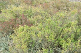
Shrubby sea- |
Suaeda vera is found all along the Chesil shoreline of the Fleet. It is a small shrub with evergeen leaves. |
|
Smallmouth |
The entrance to the Fleet from Portland Harbour. Now in two parts since the new bridge was built and a new channel excavated. The old channel is now a small harbour and beach. |
|
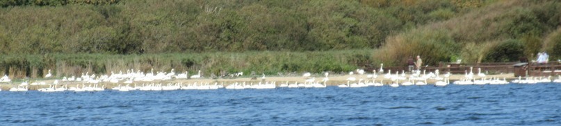
SPA |
Special Protection Area. Chesil Beach and the Fleet is designation UK9010091. SPA’s are designated under the Conservation of wild birds Directive. The Fleet is designated for two species: the little tern, Sterna albifrons, and the widgeon, Anas penelope. |
|
South- |
The South- |
|
SSSI |
Site of Special Scientific Interest. Chesil Beach and the Fleet Lagoon are a designated SSSI. Visit the Natural England website for details and a map. |
|
Strangways Castle SY565849 |
Located on a hill overlooking Chesil Beach near Abbotsbury. It was built by the Strangways family in the late 18th Century. It was destroyed by fire in 1913 and although rebuilt it was not re- |
|
Streams |
A number of streams enter the Fleet. The main streams are at Abbotsbury and Langton Hive. Other streams are at Herbury, Fleet House, Butterstreet, and Chickerell Hive. |
|
Sub- SY563851 |
Located between Abbotsbury and Chesil Beach. Established in 1765 as the kitchen garden for the nearby Strangways Castle. Click here for more details |
|
Swannery SY575841 |
Located on the north shore of the upper Fleet near Abbotsbury. Click here for more information. |